
Measure How People Use Outdoor Spaces
Real-time recreation analytics for trails, parks, trailheads, transportation corridors, and public spaces.
Solar-powered AI sensors measure visitation, activity types, occupancy, and usage patterns — without permanent infrastructure — so agencies and planners can answer the questions that drive decisions.
Problems We Solve
Answers to the questions agencies and planners actually ask
Trail Monitoring
Count users and identify activity types across your trail network.
Trailhead Analytics
Understand access-point demand, congestion, and peak fill times.
Multimodal Transportation
Monitor walking, biking, and shared-use corridors and crossings.
Park Usage
Measure activity throughout parks and recreation facilities.
Occupancy Monitoring
Track usage of courts, playgrounds, boat launches, and public assets.
Planning & Research
Generate defensible datasets for studies and grant applications.
Why Waypoint
Deploy anywhere
Solar + cellular, no permanent infrastructure
- No power, no network, no trenching
- Temporary or permanent placement
- Deploy in hours, not months
Understand more than counts
Activity, direction, and occupancy
- Classify activity types automatically
- Determine travel directionality
- Measure occupancy of spaces and assets
Defensible data
Image-validated observations you can audit
- Fewer false positives than IR
- Explainable, reviewable anomalies
- Credible to boards and grant reviewers
Solutions
Built for the spaces you manage
Trails
Count users and understand what's driving growth across your trail network.
Trailheads
Understand access-point demand, congestion, and which trailheads drive usage.
Parks
Measure activity and amenity demand throughout parks and recreation areas.
Recreation Facilities
Track occupancy of courts, playgrounds, skateparks, boat launches, and more.
Transportation & Mobility
Monitor walking, biking, and shared-use corridors, crossings, and complete streets.
Research & Planning
Generate defensible observational datasets without staffing field crews.
Outcomes
Data that turns into decisions
Optimize maintenance investments
Direct maintenance dollars to the trails and assets that carry the most use.
Support grant applications
Back funding requests with defensible, image-validated usage data.
Validate capital projects
Measure usage before and after to prove the impact of your investments.
Understand peak demand
Plan staffing, access, and capacity around real high-traffic windows.
Improve visitor experience
Reduce congestion and conflicts by acting on how people actually use spaces.
Proven in the Field
Successful Deployments
VisionAI One has been validated across diverse trail environments in partnership with park districts, transportation agencies, and municipalities—confirming detection accuracy, system reliability, and data quality in real-world conditions.
Hyland Lake Park Reserve
Three Rivers Park District
Multimodal, multistation trail monitoring across multiple recreation areas within a regional park system
Bloomington, Minnesota
Nine Mile Creek Pedestrian Bridge
Minnesota Department of Transportation
Pedestrian and trail-user crossing study on a transportation asset, with directionality and volume analysis
Minnesota
Portage Avenue Pedestrian Use Study
City of Mora
Municipal pedestrian-use monitoring measuring walking patterns and time-of-day activity along an urban corridor
Mora, Minnesota
Lake Girard Trail System
Independent deployment
Multimodal, multistation activity monitoring on popular trail networks and water access points
Minnesota
Partners & Memberships

Overview
Waypoint is building the first AI-powered telemetry infrastructure for outdoor recreation.
Our system combines rugged autonomous field sensors with computer vision models to measure recreational activity on trails, parks, and public lands—delivering real-time, defensible data without permanent infrastructure.
Unlike traditional infrared counters, Waypoint uses AI detection and tracking algorithms to identify individual trail users, classify activity types, and filter noise—producing research-grade datasets for planning and management decisions.
Hardware Collection
Autonomous sensors designed for remote, off-grid deployment
Data Analysis
AI-powered analytics platform for trends and insights
Why Waypoint Telemetry Is Different
Technical Infrastructure for Recreation Measurement
Waypoint combines computer vision AI, autonomous field sensors, and real-time telemetry infrastructure to deliver research-grade recreation data—eliminating the limitations of traditional infrared counters.
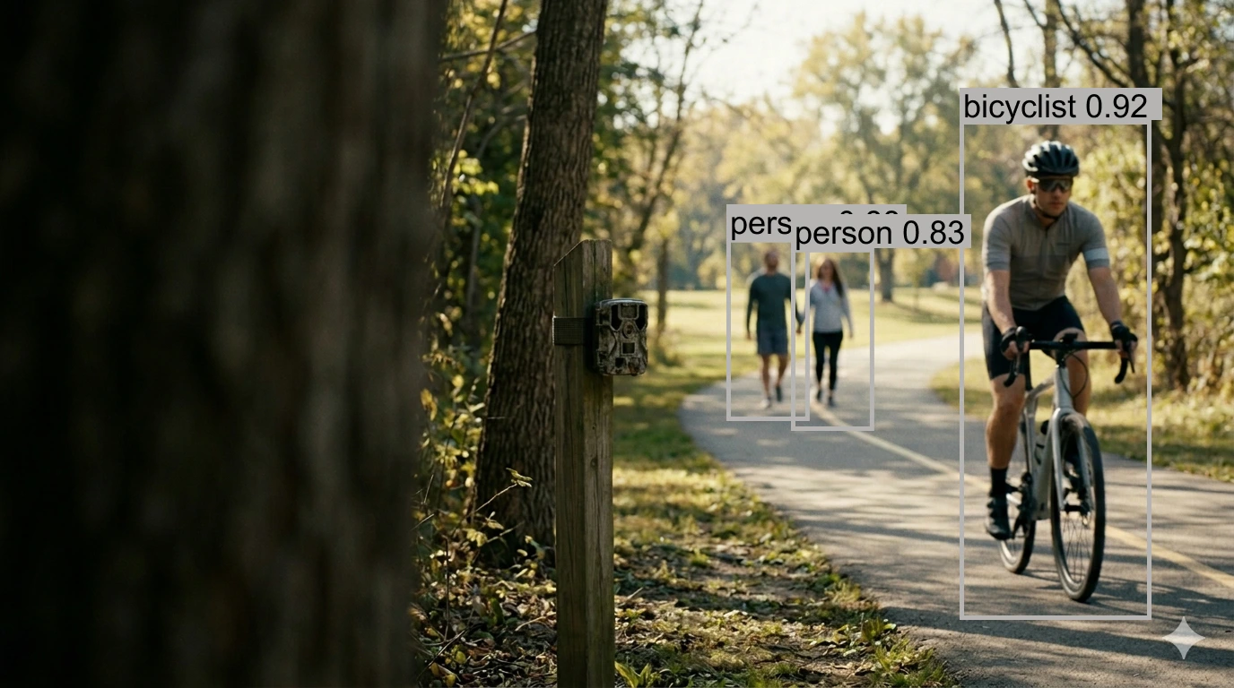
Computer Vision AI Models
Our proprietary computer vision pipeline detects, tracks, and classifies trail users—automatically processing raw imagery into accurate, research-grade datasets.
Multi-frame tracking algorithms suppress duplicates and filter noise, producing defensible counts for planning and grant reporting.
- Activity classification (walk, run, bike)
- Duplicate suppression & noise filtering
- Directional flow analysis
AI-powered accuracy — not simple beam breaks.
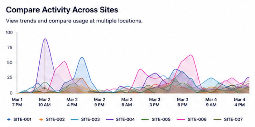
Real-Time Telemetry
Our platform leverages in-field devices equipped with cellular connectivity and a scalable cloud infrastructure to deliver near real-time data and analytics.
As data is captured in the field, it's automatically processed and visualized in our platform — giving you up-to-date insights across all sites.
Perfect for:
- Outdoor recreation monitoring
- Usage analytics
- Planning & resource management
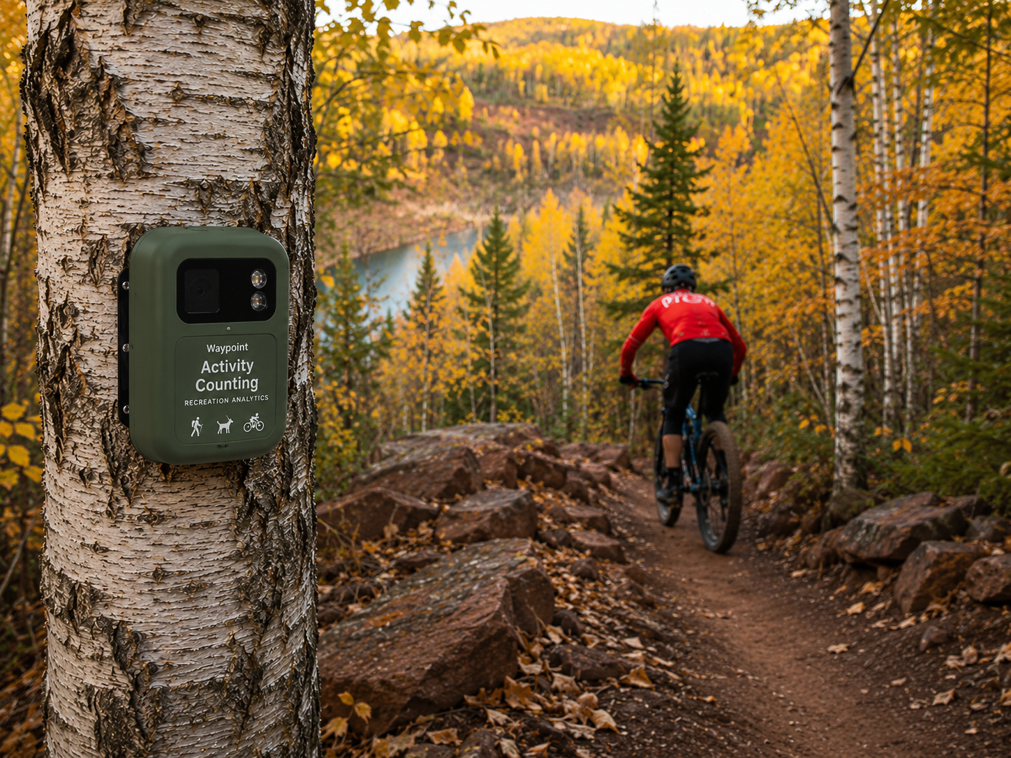
Autonomous Telemetry Infrastructure
Solar-powered field sensors with integrated cellular connectivity eliminate the need for site visits, SD card retrieval, local WiFi, or battery swaps.
Continuous data collection and transmission enable real-time monitoring across distributed recreation sites—without permanent power or network infrastructure.
- Deploy in hours, not months
- Minimal maintenance across seasons
- Dramatically reduced operational costs
Real-time infrastructure without the infrastructure.
Interested in collaborating?
We welcome conversations with land managers, conservation organizations, government agencies, and research partners interested in exploring pilot programs or learning more about the initiative.