Best Trail Counters for Parks (2026): Comparing Infrared, Inductive, and AI Systems
Agencies searching for the best trail counters for parks are often comparing traditional infrared systems with newer technologies like inductive loops and AI-based camera systems. As trail usage data becomes more important for planning, funding, and infrastructure decisions, many organizations are moving beyond simple count data toward systems that provide accurate, classified, and defensible insights.
Field studies have shown that traditional infrared trail counters can undercount usage by approximately 20% in real-world conditions due to group behavior and occlusion -- a gap that grows larger at high-traffic sites where accurate data matters most.
This guide compares the four major trail counter technologies available in 2026 -- infrared (PIR), inductive loop, pressure/pneumatic, and AI-based camera systems -- so park agencies, city planners, DOTs, and environmental consultants can make informed decisions about their trail monitoring infrastructure.
Types of Trail Counters
Each trail counter technology uses a different detection method, which determines what data it can collect, where it performs best, and what limitations agencies should expect.
Infrared (PIR) Counters
Passive infrared trail counters detect changes in heat radiation when a person or object crosses a sensor beam. Each beam-break event is logged as a single count. Infrared counters are the most widely deployed trail counting technology, used by park agencies and DOTs across North America for decades.
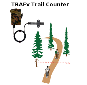
Image: TRAFx Research
Strengths
- +Simple deployment with minimal site preparation
- +Low power consumption with multi-month battery life
- +Large installed base with established vendor support
- +Lower per-unit hardware cost
Limitations
- -Undercounts groups walking side-by-side or close together (up to ~20% undercount in group scenarios)
- -False triggers from wildlife, vegetation, and temperature fluctuations
- -Cannot classify users (bike vs pedestrian vs runner)
- -No visual validation or auditability of count data
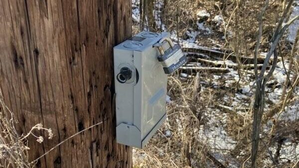
A typical TRAFx infrared counter installation on a trailside post. These units are compact and low-profile but limited to total event counts. Image: Delaware & Lehigh National Heritage Corridor
Inductive Loop Counters
Inductive loop counters detect metallic objects passing over a wire loop embedded in or placed on the trail surface. They are designed primarily for bicycle detection, sensing the metal in bike frames and wheels as they cross the loop.
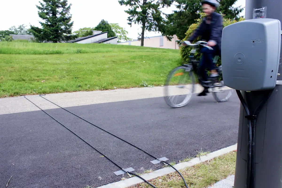
An Eco-Counter MULTI installation showing the inductive loop tubes embedded in the pavement surface. Dual tubes enable directional detection but require permanent surface modifications. Image: Eco-Counter
Strengths
- +High accuracy for bicycle-specific counting
- +Unaffected by weather and lighting conditions
- +Can measure direction with dual-loop configurations
Limitations
- -Cannot detect pedestrians (no metal to sense)
- -Requires pavement cuts or surface installation
- -Limited to paved or hardened surfaces
- -Not suitable for mixed-use trail monitoring
Pressure and Pneumatic Counters
Pressure-based systems use pneumatic tubes or pad sensors installed on or beneath the trail surface to detect foot traffic or wheel crossings. These systems register a count when sufficient pressure is applied to the sensor.

An Eco-Counter Nature unit installed beside a paved path. Permanent installations like these require site preparation and ongoing maintenance. Image: Eco-Counter
Strengths
- +Can detect both bikes and pedestrians
- +Low visibility on the trail surface
Limitations
- -Subject to wear and environmental damage
- -Limited classification capability
- -Maintenance-intensive in outdoor environments
- -Niche use cases (primarily temporary count studies)
AI-Based Trail Counters
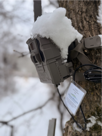
AI-based trail counting represents the newest generation of monitoring technology. Systems such as Waypoint's VisionAI One use solar-powered cellular cameras paired with computer vision models to detect, classify, and count trail users from imagery.

AI-based detection systems use computer vision to identify and classify individual trail users. Yellow boxes indicate pedestrians; green boxes indicate cyclists. Image: Eco-Counter
Waypoint VisionAI One
Waypoint's VisionAI One is a solar-powered, cellular-connected AI trail counter purpose-built for remote outdoor environments. It combines on-device computer vision with cloud-based processing to deliver classified, image-validated trail usage data without site visits or manual downloads.
Core Capabilities
- •Camera-based detection: Observes trail activity directly rather than sensing heat or metal
- •Activity classification: Distinguishes between pedestrians, cyclists, runners, and dogs
- •Directionality: Determines travel direction for each individual detected
- •Deduplication: Tracks individuals across frames to avoid double-counting
- •Image validation: Every count is backed by source imagery for auditing and verification
AI trail counting systems process imagery automatically, replacing what previously required approximately 40 hours of manual video review per site with automated detection workflows. This makes continuous, classified monitoring practical at scale.
Trail Counter Comparison: Technology Overview
The following table summarizes how each trail counter technology performs across the capabilities that matter most for park agencies and transportation planners.
| Capability | Infrared (PIR) | Inductive Loop | Pressure | AI (VisionAI One) |
|---|---|---|---|---|
| Overall Accuracy | Moderate | High (bikes only) | Moderate | High |
| Bike Detection | Partial | Yes | Partial | Yes |
| Pedestrian Detection | Yes | No | Yes | Yes |
| Classification | No | No | No | Bike, pedestrian, runner, dog |
| Directionality | Dual-beam only | Dual-loop only | No | Full directional analysis |
| Data Validation | Manual only | Manual only | Manual only | Image-backed verification |
| Relative Cost | Low | Medium | Medium | Medium |
| Best Use Case | Low-traffic, simple counts | Bike-specific infrastructure | Temporary count studies | Mixed-use trails, planning, funding |
Accuracy and Real-World Performance
Trail counter accuracy varies significantly depending on the technology, site conditions, and traffic patterns. Understanding these performance differences is essential for agencies evaluating the best trail counters for their monitoring programs.
Infrared Undercounting in Group Scenarios
Field studies comparing PIR counters to video-based ground truth have consistently measured undercounting rates of approximately 20% at shared-use trails with regular group travel. The primary cause is occlusion: when two or more people walk side-by-side or in close succession, the sensor registers only a single beam-break event.
Group behavior -- families walking together, friends side-by-side, close-following on busy weekends -- is the single largest source of systematic error in infrared trail counting. This undercounting compounds at high-traffic sites where groups are most common.
How AI Vision Systems Improve Accuracy
Camera-based AI trail counting systems observe trail users directly and count individuals within groups, regardless of their formation or spacing. By analyzing imagery rather than heat signatures, these systems avoid the occlusion problem that limits infrared counters.
AI systems also filter false triggers automatically. While infrared counters can be activated by wildlife, moving vegetation, or thermal fluctuations, computer vision models identify only human trail users (and dogs, when configured), producing cleaner count data without manual correction.
Eliminating the Manual Review Burden
Agencies that previously relied on manual video review to validate counter data or conduct classified counts can now automate that process entirely. What once required approximately 40 hours of staff time per site to review video footage and tally bike and pedestrian counts is handled by AI models processing images continuously.
Related reading: For a detailed examination of accuracy rates across counter technologies, see our guide on trail counter accuracy and calibration methods.
When Each Technology Makes Sense
No single trail counter technology is optimal for every situation. The best choice depends on site characteristics, data requirements, and budget constraints.
Many agencies evaluating the best trail counters are specifically looking for an alternative to traditional infrared systems like Eco-Counter as they encounter limitations around accuracy and classification on mixed-use trails.
Infrared Counters
Best for: Low-traffic, single-use trails where simple total counts are sufficient and group travel is infrequent. Ideal when per-unit cost is the primary constraint and general trend data meets planning needs.
Inductive Loop Counters
Best for: Bike-specific infrastructure such as protected bike lanes, commuter paths, and paved bike trails where only bicycle counts are needed. Requires paved or hardened surfaces.
AI-Based Trail Counters
Best for: Mixed-use trails, high-traffic sites, and locations where classified bike and pedestrian counts, directional data, or defensible data for funding applications are required. The best trail counter choice when agencies need comprehensive trail usage data.
Hybrid Deployments (IR + AI)
Best for: Large trail networks where agencies need wide spatial coverage at reasonable cost. Infrared counters provide baseline counts at most sites while AI systems at high-priority locations provide classified data, validation, and correction factors that improve the accuracy of the entire network.
Trail Counter Pricing: What to Expect
Pricing varies widely across trail counting technologies, and differences in total cost of ownership are often driven more by data collection methods, labor requirements, and analytical capabilities than by hardware alone. Agencies should consider connectivity fees, subscription models, data retrieval logistics, and the depth of analysis each system supports.
Basic Infrared Counters
Entry-level infrared counters from manufacturers like TRAFx start at around $2,500 for a complete starter package, with additional counter units available for approximately $800 each. While individual units are inexpensive, the initial investment includes the base station and software needed to operate the system. Most units at this price point do not include cellular connectivity, so data retrieval requires manual site visits via USB or Bluetooth.
For agencies that need general trend data at lower-traffic sites, basic infrared counters remain a practical and budget-friendly choice. However, the labor involved in manual data collection and the limited analytical depth (total counts only, no classification or directionality) are worth factoring into the total program cost -- particularly at sites where data quality supports funding or planning decisions.
Infrared with Cellular Connectivity
Infrared counters with built-in cellular connectivity from established providers like Eco-Counter typically fall in the $3,000–$5,000 range per unit, with ongoing subscription fees for data transmission and cloud platform access. The addition of cellular eliminates manual data retrieval, which can be a meaningful operational improvement for agencies managing multiple sites.
The underlying detection method remains infrared, so agencies gain remote access and ease of data collection but continue to work within the inherent limitations of PIR-based counting -- including group undercounting and the absence of user classification. For some programs, that tradeoff is acceptable; for others, it may not match evolving data requirements.
AI Camera Systems
Agencies can expect to pay anywhere from $7,000–$10,000 per unit for the newest AI camera counting technology from established providers like Eco-Counter, typically with additional subscription fees for cloud processing and data access. These systems offer classification capabilities and represent a significant step forward in data depth from traditional infrared.
At this price point, total program costs for multi-site deployments can scale quickly -- particularly when ongoing subscriptions, installation, and cloud processing fees are included. Agencies should evaluate whether the total cost of ownership aligns with their budget and monitoring scope.
AI-Native Alternatives
Newer entrants like Waypoint Telemetry are offering similar AI-based trail counting technology at a much lower cost. VisionAI One was designed from the ground up as an AI-native system, with solar power, cellular connectivity, and cloud-based AI processing built into the platform rather than layered on as separate subscriptions.
For agencies that need the analytical depth of AI-based counting -- classification, directionality, image validation -- but are working within tighter budgets, AI-native systems offer a path to that data without the multi-tiered pricing structures that have historically characterized this market.
Key takeaway: The cheapest trail counter is not always the most cost-effective. Agencies should weigh the total cost of ownership -- including data retrieval labor, subscription fees, and the analytical value of the data produced -- against their monitoring goals. Understanding what each price tier actually delivers in terms of data depth and operational overhead is essential to making the right investment.
Why Agencies Are Moving to AI-Based Trail Counters
Several converging trends are driving park agencies, DOTs, and environmental consultants to evaluate AI trail counting systems alongside or in place of traditional counters.
Higher Accuracy Expectations
As trail systems receive larger capital investments, the tolerance for systematic counting error decreases. A 20% undercount that was acceptable for general trend monitoring becomes problematic when trail usage data drives million-dollar infrastructure decisions or staffing allocations.
Funding Justification
Federal and state grant programs increasingly require demonstrated trail usage data with classified counts. Programs like the Federal Highway Administration's Bicycle and Pedestrian Count Program call for mode-specific data that infrared counters cannot provide. Agencies need defensible, image-validated counts to support applications.
Modern Planning Needs
Contemporary recreation and transportation planning requires understanding when different user types are on trails, in which direction they travel, and how usage patterns change across seasons. These questions cannot be answered by total event counts alone. Agencies need richer analytical data that supports evidence-based decision making.
Infrared vs AI: Which Trail Counter Should You Choose?
For most agencies, the decision comes down to infrared or AI. Here is a practical framework for choosing the right trail counter for your sites.
Choose Infrared If:
- •Your sites have low traffic with mostly solo users
- •You need only rough total counts, not classified data
- •Your budget prioritizes maximum site coverage over data depth
- •General usage trends are sufficient for your planning needs
Choose AI (VisionAI One) If:
- •You need accurate counts on busy, mixed-use trails
- •You need classified bike and pedestrian counts
- •You need defensible data for grants and funding applications
- •You need directional tracking and travel pattern analysis
- •You need image-backed validation and data auditability
- •You need to meet federal multimodal reporting standards
What Is the Best Trail Counter for Parks?
The best trail counter for parks depends on the agency's monitoring goals, site conditions, and data requirements. For low-traffic trails where only a rough total count is needed, infrared counters remain a practical and cost-effective option. For bike-specific corridors on paved surfaces, inductive loops offer high accuracy.
However, for mixed-use trails where agencies need classified bike and pedestrian counts, directional data, and defensible numbers for funding applications, AI-based camera systems provide the most comprehensive data. Hybrid deployments that combine infrared counters with AI systems at strategic locations offer agencies the best balance of spatial coverage and data depth.
In short: the best trail counter is the one that matches your data needs. Agencies that require only total counts can use infrared. Agencies that need classified, validated, defensible trail usage data should evaluate AI-based systems like VisionAI One.
Real-World Pilot Results
In pilot deployments, agencies running VisionAI One alongside existing infrared counters have observed consistent, measurable differences in data quality and completeness.
Side-by-Side Comparison Findings
At shared-use regional trails, the AI system consistently detected 15-25% more trail users than co-located infrared counters during peak hours. The largest discrepancies occurred on weekend mornings when family groups, dog walkers, and side-by-side pedestrian traffic were most common.
Beyond raw count differences, pilot agencies gained access to classified data -- bike vs pedestrian breakdowns, directional splits, and hourly activity composition -- that their infrared counters could not provide. Several agencies cited this classified data as the deciding factor in their evaluation.
For detailed results from specific deployments, see our Hyland Lake Park Reserve pilot study and Lake Girard pilot study.
Waypoint VisionAI One: Purpose-Built for Trail Environments
VisionAI One is designed specifically for outdoor trail monitoring, addressing the operational challenges that make general-purpose camera systems impractical for remote trail sites.
VisionAI One
Solar-Powered Deployment
Operates autonomously on solar power with no external power connections required. Designed for remote trailheads, park paths, and locations without infrastructure access.
Cellular Connectivity
Transmits data automatically via cellular networks. No Wi-Fi, manual downloads, or site visits required to access trail usage data.
AI-Based Classification
Computer vision models classify every detected trail user by activity type -- pedestrian, cyclist, runner, or dog -- producing structured bike and pedestrian counts automatically.
Image-Validated Data
Every count is backed by source imagery. Agencies can audit detection results, verify accuracy, and demonstrate data quality to stakeholders and funding agencies.
See also: Learn how VisionAI One compares to traditional infrared systems in our detailed infrared vs vision-based monitoring comparison, or read about real-world accuracy differences on our Eco-Counter alternative page.
Evaluate VisionAI One at Your Trail Sites
Run a pilot deployment at your site and compare VisionAI One directly against your existing trail counters. Most agencies see measurable differences in accuracy, classification, and data quality within the first few weeks.
We work with park agencies, DOTs, and environmental consultants to deliver fast time to insight with classified, image-validated trail usage data.
Related Resources
Eco-Counter Alternative
How AI-powered trail counting compares to traditional infrared counter systems like Eco-Counter.
Read comparison →Trail Counter Accuracy
Accuracy rates, calibration methods, and validation protocols for trail counting systems across technology types.
Read guide →Infrared vs Vision Systems
Research-backed comparison of infrared counter accuracy versus camera-based vision monitoring systems.
Read comparison →