VisionAI One™
Trail Intelligence System
Replace infrared counters with a vision-based system that delivers real-time, image-validated trail usage data you can trust.
What It Is
A complete trail intelligence system — hardware, AI, and analytics
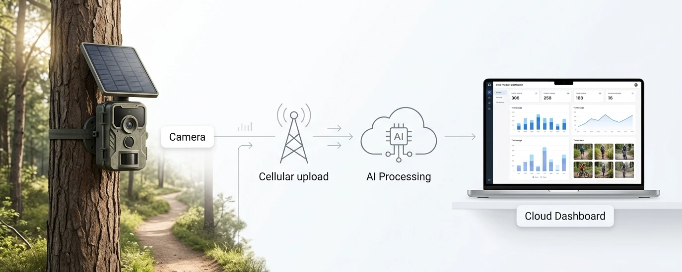
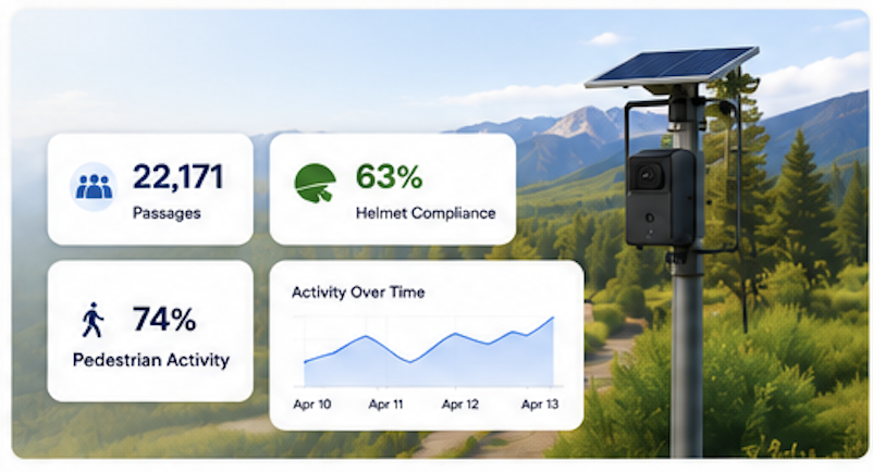
VisionAI One is a solar-powered, cellular trail camera system with built-in AI and a cloud dashboard. Stop estimating trail use. Start seeing it.
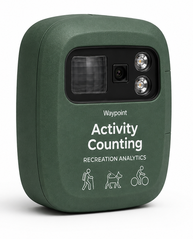
Cellular Trail Camera
Solar-powered, always-on monitoring in remote locations. No trenching, no permanent installs, no site visits to retrieve data.
AI Detection Engine
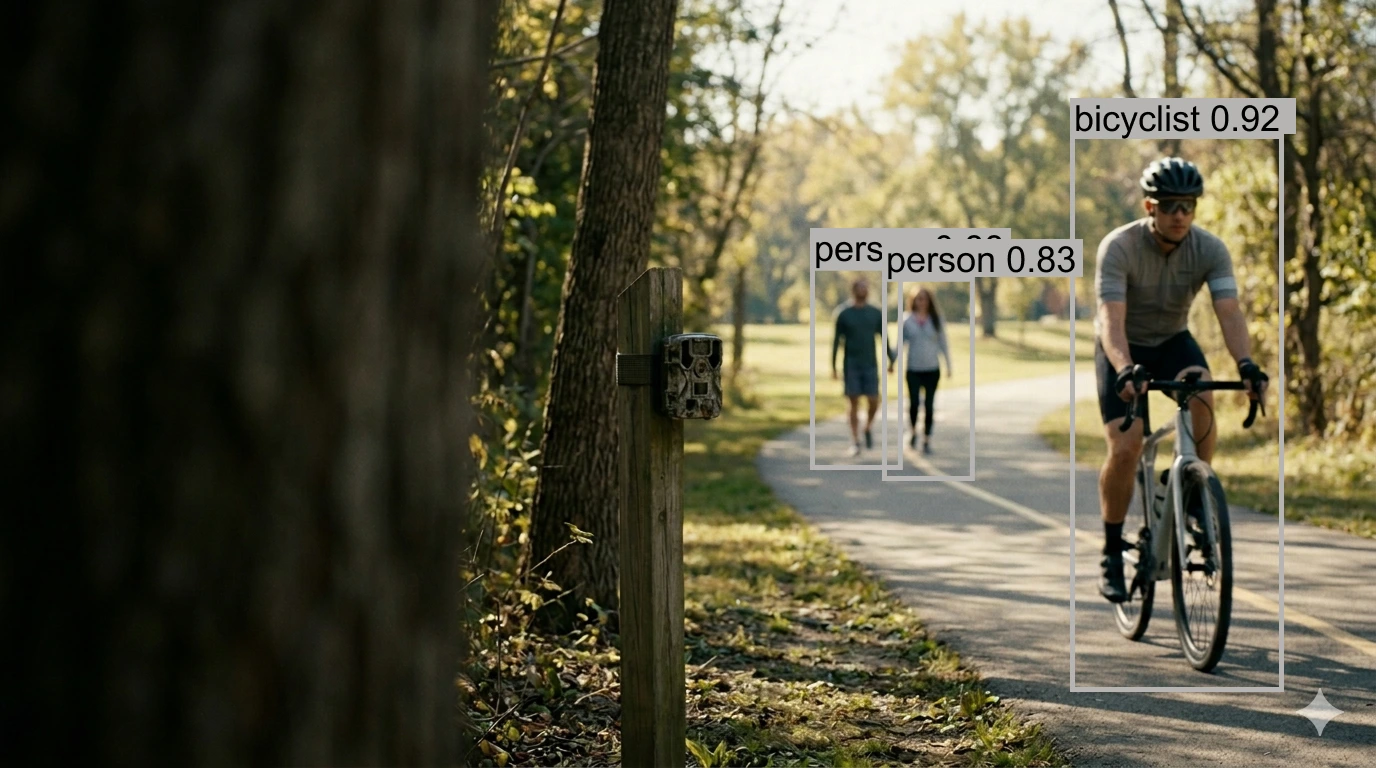
Computer vision models identify people, bikes, dogs, and more — with duplicate filtering and directional tracking built in.
Cloud Dashboard
Real-time analytics, activity breakdowns, directional flow charts, image-backed validation, and exportable reports.
No manual downloads. No guesswork. No black boxes.
Core Capabilities
What VisionAI One measures
Activity Classification
Know exactly how trails are used — bikes vs walkers vs dogs vs other activity types.
Directional Flow
Understand movement patterns — inbound vs outbound, corridor behavior, origin analysis.
Image-Validated Counts
Every data point can be verified visually. No more black-box skepticism from stakeholders.
Continuous Monitoring
No rotating counters, no gaps in data. Always-on coverage across your trail network.
Remote Deployment
Works anywhere with cellular signal. No power, no WiFi, no infrastructure required.
Trend Analysis
Seasonal patterns, peak hours, long-term growth — data that drives planning decisions.
Use Cases
Built for the people managing outdoor spaces
Deploy cameras across a trail network and monitor all activity from a single dashboard — no site visits, no manual downloads.
Trail Planning & Expansion
Data-driven evidence for where to build, widen, or reroute trails based on actual usage patterns.
Capacity & Congestion Management
Real-time visibility into crowding at trailheads, parking areas, and high-use corridors.
Seasonal Usage Analysis
Understand how activity shifts across seasons to plan staffing, maintenance, and programming.
Multi-Use Conflict Resolution
Quantify the mix of bikes, pedestrians, and other users to inform trail-sharing policies.
Grant Reporting & Compliance
Defensible, image-backed usage data for grant applications and required reporting.
Before & After Studies
Measure the impact of trail improvements, new infrastructure, or policy changes with baseline data.
Why It Exists
Traditional counters were never designed for modern trail systems
Infrared beam counters miss groups, can't distinguish activity types, and produce data nobody can verify. VisionAI One was built to fix that.
Result: More accurate data. Less fieldwork. Higher confidence decisions.
What You Get
Three layers working together
Field Hardware
- Cellular trail camera with integrated solar panel
- LTE connectivity — no WiFi or wired infrastructure
- Weather-resistant, rated for year-round outdoor use
- Strap-mount deployment in minutes, not hours
- No trenching, no permanent installs
AI Processing Pipeline
- Object detection (YOLO-based models)
- Duplicate filtering via person re-identification
- Directional movement analysis
- Activity classification — bikes, pedestrians, dogs
- Environmental tagging (lighting, conditions)
- Weather data integration
Cloud Dashboard
- Real-time counts — data within minutes of capture
- Activity breakdowns (bike vs pedestrian vs other)
- Directional flow charts
- Image-backed validation for every data point
- Exportable reports for planning and grants
How It Works
From install to insight in minutes
Install camera on site
Strap-mount to a tree or post. 5-10 minutes. No tools required.
Camera captures activity on motion
Images are taken automatically when trail users pass through the field of view.
Images uploaded via cellular
Data is transmitted over LTE to the cloud — no SD cards, no site visits.
AI processes detections
Computer vision models detect, classify, and deduplicate trail users.
Results appear in your dashboard
Counts, activity types, direction, and validation images — all in real time.
Latency: ~5-15 minutes from capture to insight in your dashboard.
Validation & Accuracy
Designed to solve the known limitations of infrared
VisionAI One directly addresses the failure modes documented in peer-reviewed trail counter literature.
Group Occlusion
Visual detection identifies individuals walking side-by-side or in clusters that IR beams count as one.
False Positive Reduction
AI distinguishes people from animals, shadows, and vegetation movement that trigger IR sensors.
Loitering & Double-Counts
Re-identification algorithms track subjects across frames, eliminating duplicate counts from lingering.
Visual Ground Truth
Every detection is linked to source imagery — enabling manual audits and stakeholder confidence.
Currently being validated in live deployments in Minnesota. Read the validation methodology
Deployment Model
Flexible to match your needs
Pilot Studies
2-4 weeks
Test the system on your trails with a short-term deployment to evaluate data quality and fit.
Seasonal Monitoring
3-6 months
Capture a full season of usage data for planning, grants, or before-and-after studies.
Permanent Installation
Ongoing
Long-term monitoring infrastructure for continuous trail intelligence at key locations.
Multi-Site Rollout
Custom
Deploy across multiple trailheads, corridors, or parks with centralized dashboard access.
Why VisionAI One
Not just a better counter — an entirely new category
Traditional counters give you numbers. VisionAI One gives you understanding.
Traditional
- Sensors
- Estimates
- Static data
- Manual workflows
VisionAI One
- Vision
- Evidence
- Rich insights
- Automated intelligence
See what your trails are actually doing
We work directly with parks, agencies, and conservation organizations to deploy VisionAI One on your trail network.
Or email directly: zach@waypointtelemetry.com