How Waypoint Works
From shipment to actionable trail insights — in days, not months.
- We ship ready-to-deploy camera systems
- You start collecting data immediately
- We deliver verified, real-time insights
End-to-End Process
A simple, end-to-end system — from trail to dashboard
Six steps between your trails and the data you need. No complex infrastructure, no IT projects, no waiting.
Plan Your Deployment
We help determine optimal camera locations based on trail layout, use case, and traffic patterns. Typical deployments range from 1 to 25+ sites.
- Site assessment based on your trail map
- Coverage recommendations for your goals
- Flexible — start small and expand over time
No prior experience required
We Ship Your System
Pre-configured, cellular-enabled cameras arrive ready to deploy. No networking equipment, no infrastructure buildout, no IT involvement.
- Solar-powered with battery backup
- Cellular connectivity built in
- Pre-configured for your deployment
Works anywhere — no WiFi or power needed
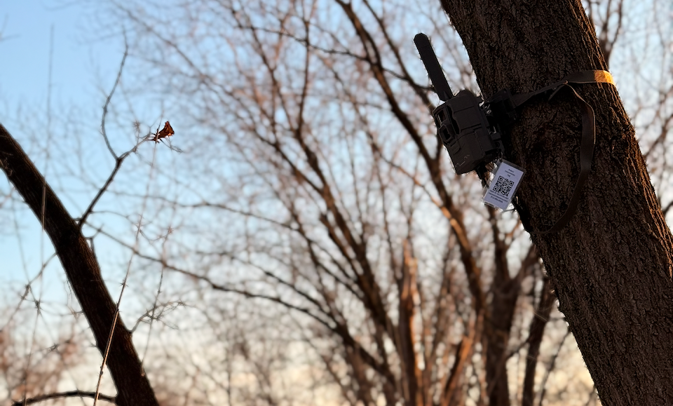
Install in Minutes
Mount cameras along trails or at trailheads with simple strap mounts. Typical install takes 10 to 15 minutes per unit. We provide placement guidance — or handle installation for you.
- Strap-mount to a tree or post
- No tools or special skills required
- Simple placement guidance included
We can handle full installation for you
Data Collection Begins Immediately
Cameras capture real-world trail activity and upload automatically via cellular. No field visits, no SD cards, no manual downloads.
- Motion-triggered image capture
- Automatic cellular upload
- Continuous, always-on monitoring
No rotating counters. No data gaps.
AI Processing + Validation
Computer vision identifies and classifies trail users, filters duplicates, and tracks directional movement. Every count is backed by source imagery you can review.
- Activity classification (bikes, pedestrians, dogs)
- Duplicate filtering and re-identification
- Directional movement tracking
No black-box estimates — every count is verifiable
Access Insights in Your Dashboard
Trail usage trends, mode split, directional flow, and peak usage times — all available within days of deployment. Export reports for grants and planning.
- Trail usage trends over time
- Bike vs pedestrian breakdown
- Directional flow analysis
- Peak usage times and patterns
Insights delivered within days of deployment
Deployment Models
Choose the model that fits your team
Whether you have field staff or want a fully managed solution, Waypoint adapts to how your organization operates.
Hardware as a Service
Best for: agencies with staff who can install
What you handle
- Install and reposition cameras as needed
What Waypoint handles
- Hardware provisioning
- Cellular connectivity
- Monitoring + uptime
- Replacements + maintenance
- Full analytics platform
All the benefits of a modern system — without owning or managing hardware.
Full-Service Deployment
Best for: agencies that want zero operational burden
Waypoint handles everything
- Site planning + camera placement
- Installation (direct or subcontracted)
- Hardware provisioning
- Cellular connectivity
- Ongoing monitoring + maintenance
- Full analytics platform
We handle everything. You just get the data.
Start Small
Start with a Pilot
Most customers start with a pilot — and expand once they see the data. A pilot lets you validate accuracy, identify key insights, and build internal confidence before committing to a full deployment.
- Typical pilot: 2 to 8 weeks
- Validate accuracy vs existing methods
- Identify key insights quickly
- Expand to full deployment if successful
Low Time Commitment
2 to 8 weeks gives you enough data to evaluate the system against your current methods.
Low Risk
No long-term contracts. No infrastructure investment. See the data before you commit.
Clear Path to Scale
Successful pilots expand naturally. Add cameras, add sites, add coverage — on your timeline.
Outcomes
What you get from a Waypoint deployment
Reliable Trail Usage Counts
Accurate, continuous counts that don't miss groups or double-count loiterers. Data you can stand behind.
Clear Mode Split
Know exactly what share of traffic is bikes, pedestrians, dog walkers, and other activity types.
Directional Movement Patterns
Understand flow — which direction people travel, where corridors are busiest, and how usage shifts over time.
Defensible Data for Funding
Image-validated, exportable reports built for grant applications, board presentations, and compliance reporting.
Ready to see what this looks like for your trails?
We work directly with parks, agencies, and conservation organizations to plan deployments that match your goals and your budget.
Or email directly: zach@waypointtelemetry.com