Real-Time Recreation Data
See how people are using trails and parks within minutes.
Waypoint converts field imagery into structured recreation telemetry in near real time. Solar-powered sensors capture activity in the field, images are transmitted over cellular networks, and computer vision models process detections in the cloud. Clean activity data is delivered to the Waypoint platform within minutes, allowing organizations to observe recreation patterns as they happen.
Why Real-Time Data Matters
Traditional recreation monitoring systems often require manual data retrieval or periodic downloads.
This means activity patterns may not be visible until days or weeks after they occur.
Waypoint enables organizations to understand recreation activity while it is happening.
Real-time insights allow agencies to:
- •monitor trail usage throughout the day
- •observe peak recreation hours
- •evaluate activity during events
- •detect unusual surges in visitation
- •better understand demand across access points
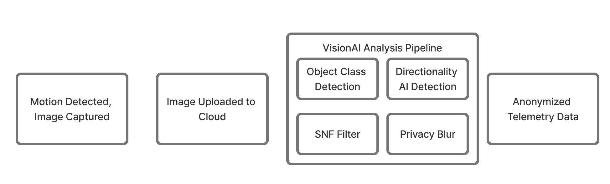
How the Real-Time System Works
Waypoint processes recreation activity through a continuous pipeline that transforms field imagery into structured telemetry.
Step 1 — Field Capture
Solar-powered cellular cameras capture images at monitoring stations.
These cameras operate autonomously and transmit imagery over cellular networks.
Step 2 — Cloud Ingestion
Images are securely uploaded to the Waypoint cloud infrastructure where they are synchronized with the processing pipeline.
Step 3 — AI Detection
Computer vision models analyze images for recreation activity, including:
- •people
- •bikes
- •vehicles
- •animals
Advanced algorithms filter duplicate detections and apply activity classification.
Step 4 — Structured Data Output
Detection results are converted into structured recreation telemetry and stored in the Waypoint analytics platform.
Step 5 — Dashboard Updates
Processed data is available in the platform dashboards within approximately 15 minutes of capture.
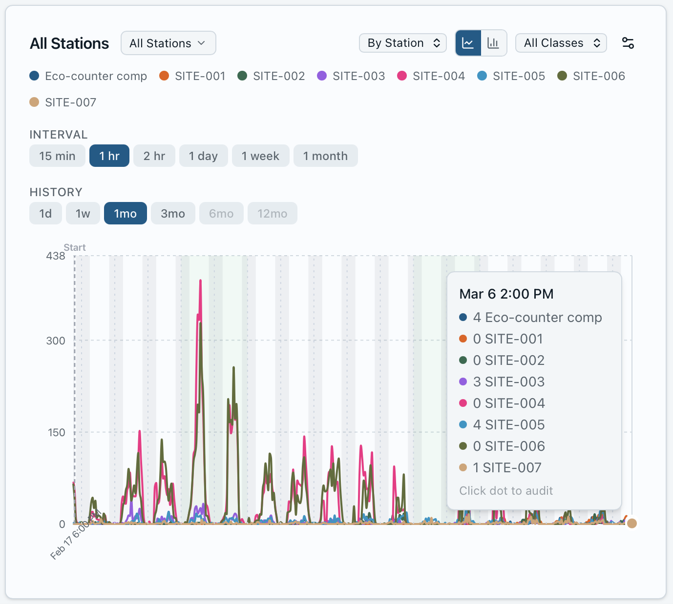
15-Minute Recreation Telemetry
Waypoint dashboards update frequently as new detections are processed.
This allows organizations to observe recreation activity at high temporal resolution.
Data can be viewed in time intervals as small as:
- •15 minutes
- •hourly
- •daily
- •seasonal
This level of detail enables a much deeper understanding of how recreation patterns evolve throughout the day.
Monitoring Activity Across Entire Park Systems
Because Waypoint sensors transmit data automatically, monitoring networks can span entire park systems.
Organizations can observe activity across multiple access points simultaneously.
Examples include:
- •comparing traffic across trailheads
- •monitoring parking areas
- •observing activity along river access points
- •evaluating trail network demand
The platform provides both map-based views and aggregated analytics.
Real-Time Insights from Hyland Park
Waypoint's real-time telemetry has been demonstrated in pilot deployments with Three Rivers Park District.
At Hyland Park, sensors continuously transmitted imagery and the AI processing pipeline produced structured recreation counts within minutes.
This pilot demonstrated that recreation telemetry can be generated automatically and viewed through the Waypoint platform in near real time.
The system enabled researchers and park managers to observe recreation activity patterns throughout the day without manual data collection.
Transparent and Auditable Data
Real-time telemetry does not sacrifice transparency.
Waypoint allows users to audit detection events and verify the AI results behind dashboard data.
Users can inspect detection samples to understand how activity counts were generated.
This combination of speed and auditability provides both operational awareness and research-grade transparency.
A New Generation of Recreation Monitoring
Waypoint brings modern telemetry capabilities to outdoor recreation infrastructure. By combining autonomous sensors, computer vision processing, and cloud analytics, the system transforms field imagery into structured data within minutes. This enables organizations to understand recreation activity across trails, parks, and access points in ways that were previously impossible.