
Looking for a TRAFx alternative?
A Modern Alternative to TRAFx Trail Counters
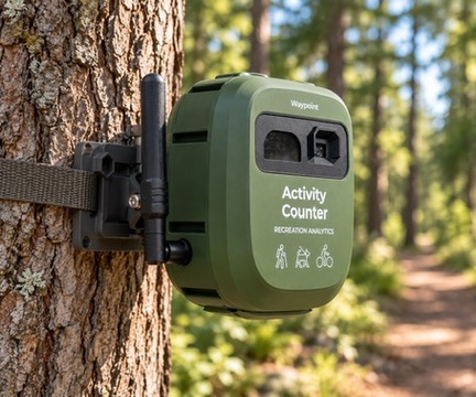
Waypoint is a Minnesota-built outdoor activity monitoring platform. Instead of a single-purpose sensor, it uses computer vision to tell parks and trail managers how many people used a location, what they were doing, which way they went, and when.
Built in Minnesota, USA. Designed, built, and supported by a U.S. company.
The Short Answer
What is Waypoint Telemetry?
Waypoint Telemetry is a Minnesota-based alternative to TRAFx for organizations that need to measure trail, park, and outdoor recreation activity. Instead of relying only on a traditional single-purpose counter, Waypoint uses AI vision to classify multiple types of activity and provide richer usage analytics.
A traditional trail counter answers one question: how many? Waypoint answers how many, what kind, which direction, when, and how a location is actually being used — from one device, with the data delivered automatically over cellular.
TRAFx is an established Canadian manufacturer whose counters have served parks and public land agencies for more than two decades. This page explains how the two approaches differ, so you can decide which fits each of your locations.
Why Now
Why organizations are evaluating alternatives to traditional trail counters
Sensor counters have given parks decades of useful trend data. What has changed is the questions agencies are being asked to answer with that data.
Mixed-use trails need a mode split
When walkers, runners, cyclists, and dog walkers share a corridor, a single total can hide the answer to the real question: who is using it, and in what proportion.
Planning questions have become more specific
Master plans, grant applications, and capital requests increasingly ask about direction of travel, peak periods, and seasonal patterns — not just annual volume.
Numbers need to hold up to scrutiny
When a count supports a funding decision, staff are asked how they know it is right. Image-backed validation gives them something to show.
Programs span many locations
Managers overseeing dozens of sites want data delivered automatically and comparable across locations in one place.
Some buyers prefer a domestic vendor
For U.S. organizations evaluating imported trail-counting equipment, a U.S.-built system with U.S.-based support can simplify procurement conversations.
Side by Side
TRAFx vs. Waypoint: two approaches to outdoor counting
TRAFx offers dedicated sensor counters, each matched to a counting application. Waypoint offers one AI vision platform configured across multiple activity types. Neither approach is right for every site — the difference is the kind of data each produces.
| Dimension | TRAFx counters | Waypoint (VisionAI One) |
|---|---|---|
| Company | TRAFx Research Ltd., Canmore, Alberta, Canada (founded 2001) | Waypoint Telemetry, headquartered in Minnesota, USA; systems designed and built in Minnesota |
| Sensing approach | Dedicated sensor counters: passive infrared for trail users; magnetometer-based counters for mountain bikes, vehicles, and OHVs | Cellular camera with cloud computer vision, configured for each site |
| Basic traffic counts | Yes — the core function of each counter | Yes |
| Activity classification | The infrared counter records all passing people as one total; mode-specific counts come from dedicated counter types such as the mountain bike counter | Classifies supported activity types from imagery — pedestrians, cyclists, runners, dogs, vehicles, and more depending on configuration |
| Direction of travel | Not captured — counters record passes as a single total | Measured from visual observations, per activity type |
| Validation data | Sensor-based counts; no imagery is captured | Representative imagery available for review where enabled |
| Data access | Counters are downloaded with the TRAFx Dock; data is managed in the web-based TRAFx DataNet | Delivered automatically over cellular to the Waypoint Cloud dashboard in real-time |
| Power | Long-life alkaline batteries with multi-year field life | Battery with external solar for long-duration deployments |
| Range of applications | Trails, mountain bike trails, winter trails, roads, and OHV routes, using the counter type matched to each | Trails, shared-use paths, trailheads and parking, parks, courts, and water access on the same hardware platform |
| Track record | Established since 2001; TRAFx reports DataNet is used by over 1,000 government organizations | Newer platform with 20 deployments across 5 states, including Minnesota park, transportation, and city partners |
TRAFx details are summarized from TRAFx's published product information, reviewed September 2026 (see sources below). Product lines change — confirm current specifications with TRAFx directly. For a technology-level comparison, see vision vs. infrared trail counters.
Richer Data
Beyond "how many?"
The same Saturday on the same trail, reported two ways. A total count tells you the trail was busy. Classified, directional data tells you who was on it and when to staff, groom, or patrol.
Traditional count
1,427
trail users
One number for the day. Useful for trends — but it can't tell you whether the trail is mostly walkers or mostly riders.
Waypoint output
- Pedestrians923 · 65%
- Bicyclists441 · 31%
- Other classified users63 · 4%
58% northbound
42% southbound
Peak 10–11 AM
Cyclists peak earlier
Imagery on file
Review any detection
Illustrative example with hypothetical numbers — not customer data. Available activity classes and outputs depend on deployment and configuration.
Learn how classification works in multimodal activity detection, how travel direction is measured in trail directionality analysis, and how it was tested in the directionality validation study.
Flexible by Design
One platform, many outdoor applications
Traditional counting programs often use a different counter type for each application. Because Waypoint classifies activity in software, the same VisionAI One hardware is configured for each location and the questions being asked there. Capabilities vary by application and are scoped during deployment planning.
Hiking trails
Visitor volumes, group travel, and seasonal demand on natural-surface trails.
Multi-use & shared-use paths
Walkers, runners, and cyclists counted separately on the same corridor.
Mountain biking & cycling
Rider volumes, direction, and how riding compares with other trail use.
Trailheads
Arrivals and activity at the access points that feed a trail system.
Parking areas
Occupancy and peak demand at trailhead and recreation-site parking.
Parks
Visitation patterns across park entrances, paths, and amenities.
Courts & facilities
Pickleball and tennis court utilization without manual observation studies.
Winter trails
Cross-country ski and winter trail activity through cold-season conditions.
River & water access
Launch and access-point activity at boat ramps and paddling sites.
Made in the USA
Built in Minnesota for parks and outdoor environments
Waypoint Telemetry is headquartered in Minnesota, and Waypoint trail monitoring systems are designed and built in Minnesota, USA. That makes VisionAI One a U.S.-built trail counter, backed by a U.S. company that develops both the hardware and the computer vision and analytics behind it.
For U.S. parks departments, park districts, cities, counties, and land managers evaluating imported trail-counting equipment, Waypoint offers a domestic option — with U.S.-based deployment planning and support from the people who build the system.
Designed and built in Minnesota
VisionAI One hardware is designed and built in Minnesota. U.S. parks and recreation organizations get an American-made trail counter from a domestic manufacturer.
U.S.-based company and support
The team that builds the system also plans deployments and supports customers — from the same Minnesota company.
Proven in Minnesota winters
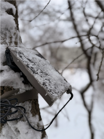
Waypoint systems have operated through a full Minnesota winter, with external solar keeping deployments running in snow and extreme cold.
A domestic purchasing option
For U.S. agencies evaluating imported equipment, a U.S.-built trail monitoring system can avoid some cross-border shipping and procurement complexity.
See where VisionAI One is designed, assembled, and tested at our Bloomington, Minnesota manufacturing and lab facility.
Minnesota deployments include Hyland Lake Park Reserve with Three Rivers Park District, the Nine Mile Creek pedestrian bridge study with MnDOT, and a pedestrian-use study with the City of Mora.
Waypoint Cloud
Modern analytics for modern parks
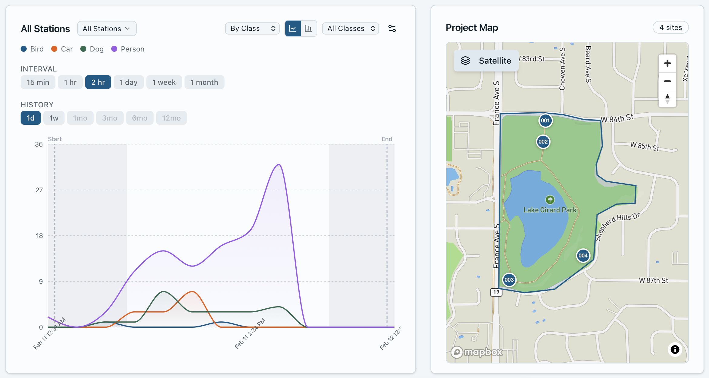
Waypoint combines the field device with a cloud analytics platform. Data is delivered over cellular and appears in a web dashboard as it is processed — no SD cards, manual downloads, or site visits to collect it.
- Trends over hours, days, and seasons
- Activity breakdowns by type
- Directional movement analysis
- Peak-period and time-of-day views
- Side-by-side site comparisons
- Integrated maps of monitoring stations
- Validation imagery for any detection
- Exports in CSV, Excel, and GIS formats
Cost
What does a Waypoint system cost compared with TRAFx?
At a high level, the two systems are relatively cost comparable, with Waypoint slightly higher than TRAFx. The bigger difference is the purchasing model. With TRAFx, you buy counters and access to the DataNet software. With Waypoint, you buy a monitoring service: the hardware, cellular connectivity, AI processing, dashboard, and support are one package.
TRAFx
Hardware purchase plus software access
- Starter package
- $2,895 USD
- Includes
- 3 counters, Dock, 3-year DataNet plan (5 users)
- Additional counters
- $645–$695 each
- Data retrieval
- Field visit with the Dock
Waypoint
Monitoring service — hardware, connectivity, and analytics
- Device deployment
- About $1,000 per device
- Annual monitoring
- About $2,000 per device per year
- Includes
- Cellular, AI processing, dashboard, support
- Data retrieval
- Automatic, in real time
TRAFx figures are from TRAFx's published pricing as of September 2026 and may change; confirm with TRAFx directly. Waypoint figures are typical pricing — final quotes depend on the number of locations, deployment length, and analytics configuration.
Beyond the line items, compare what each system delivers for the money:
- How data is retrieved — automatic delivery versus field downloads
- What each location produces — a total count, or classified, directional, image-validated data
- How many devices it takes to answer your questions across different activity types
- Staff time for site visits, downloads, and data management over the life of the program
Replacement
Can Waypoint replace existing TRAFx counters?
For organizations that primarily need counts and usage analytics, Waypoint can be evaluated as an alternative for new locations, replacement projects, or expansion of an existing counting program.
Waypoint is a separate system with its own hardware, cellular connection, and dashboard — it does not use TRAFx hardware or TRAFx DataNet. Common approaches:
Side-by-side pilot
Install a Waypoint device next to an existing counter for a season to compare results and calibrate expectations.
New locations
Use Waypoint where you are adding monitoring and need classified or directional data from day one.
Replacement at priority sites
Replace counters at high-traffic or mixed-use sites where a total count no longer answers the questions being asked.
Hybrid network
Keep existing counters for long-running baseline sites and add Waypoint where richer data matters most.
When a traditional counter may be the better fit
Simple sensor counters like TRAFx have real strengths: they are compact, run for years on standard batteries, and have a large installed base. A traditional counter may be the right choice when:
- You only need a total count at a location
- The lowest hardware cost per location is the deciding factor
- The site has no usable cellular coverage
- You need a very small, unobtrusive device left unattended for years
- Continuity with a long historical record is the top priority
Many agencies run both: traditional counters for baseline coverage, and Waypoint where classified, directional, image-validated data matters most. See how trail counter technologies compare.
FAQ
TRAFx alternative: frequently asked questions
What are the best alternatives to TRAFx trail counters?
The right alternative depends on the data you need. Other sensor-based counters (infrared, magnetometer, inductive loop, and pneumatic systems) provide similar total counts. For organizations that want more than a total — activity classification, direction of travel, time-of-day patterns, and image-backed validation — AI vision systems are the main alternative category. Waypoint Telemetry is a Minnesota-based, U.S.-built AI vision option designed for trails, parks, and outdoor recreation sites.
How is Waypoint different from a TRAFx counter?
TRAFx builds dedicated sensor counters: a passive infrared counter for trail users and magnetometer-based counters for mountain bikes, vehicles, and off-highway vehicles. Waypoint uses a cellular camera and cloud computer vision instead. One Waypoint device can classify supported activity types, measure direction of travel, and deliver data automatically to a web dashboard with validation imagery available for review.
Is Waypoint Telemetry made in the USA?
Yes. Waypoint Telemetry is headquartered in Minnesota, and Waypoint trail monitoring systems are designed and built in Minnesota, USA. Deployment planning and support come from the same U.S.-based team.
Can Waypoint count pedestrians and bicycles separately?
Yes. Waypoint uses computer vision to classify each detection, so pedestrians and bicyclists are reported as separate counts from a single device. Depending on configuration, Waypoint can also distinguish runners, dogs, vehicles, and other supported activity types.
Can Waypoint determine direction of travel?
Yes. Waypoint measures direction of travel from visual observations, so you can see inbound versus outbound movement or directional splits for each activity type.
Can Waypoint be used for mountain bike trails?
Yes. VisionAI One mounts to a tree or post beside singletrack and counts riders and hikers separately, so trail managers can see how much of a trail's use comes from mountain bikers, when riding peaks, and which direction riders travel.
Can Waypoint monitor multi-use trails?
Yes. Multi-use trails and shared-use paths are where activity classification matters most. Waypoint reports the mix of walkers, runners, cyclists, and other supported users on the same corridor, along with direction of travel and peak periods.
How much does Waypoint cost compared with TRAFx?
The two are broadly comparable in cost, with Waypoint typically slightly higher. Waypoint is priced as a service: about $1,000 per VisionAI One device for deployment plus about $2,000 per device per year for monitoring, which covers cellular connectivity, AI processing, the Waypoint Cloud dashboard, and support. TRAFx sells hardware plus software access: its published starter package is $2,895 USD for three counters, a Dock, and a three-year DataNet plan, with additional counters at $645 to $695 each. When comparing, weigh the type and depth of data each system produces and how data is retrieved. Request a quote for pricing specific to your sites.
Can I replace existing TRAFx counters with Waypoint?
Waypoint is a separate system with its own hardware, cellular connection, and dashboard; it does not use TRAFx hardware or TRAFx DataNet. Organizations evaluate Waypoint for new locations, for replacement projects, or to expand an existing counting program. Running a Waypoint device alongside an existing counter during a pilot is a practical way to compare results and maintain continuity with historical records.
Does Waypoint work in remote parks and trail systems?
Yes, where cellular coverage is available. VisionAI One runs on battery with external solar and connects over cellular networks, so it needs no Wi-Fi, utility power, or trenching. Waypoint checks cellular coverage at each proposed location during deployment planning.
Evaluating TRAFx or replacing an existing counter?
See what richer trail data looks like. Tell us about your sites and what you need to measure, and we'll help scope a pilot — including side-by-side with a counter you already own.
Or see the hardware: VisionAI One trail and park counter
Related resources
Best Trail Counters for Parks
Infrared, magnetometer, inductive loop, pressure, manual, and AI counting compared.
Vision vs. Infrared Counters
Research-backed comparison of infrared and camera-based trail monitoring.
Trail Counter Accuracy
Accuracy rates, calibration methods, and validation protocols across technologies.
Eco-Counter Alternative
How AI trail counting compares with Eco-Counter infrared systems.
Sources for TRAFx product information (reviewed September 2026): TRAFx — Products; TRAFx — Sales and pricing; TRAFx — Frequently asked questions; TRAFx — About.
TRAFx is a trademark of its respective owner. Waypoint Telemetry is not affiliated with or endorsed by TRAFx.